Thursday 19 December 2013

Innocent And Under Threat


A new report has stated that 17% of America's threatened and endangered species are at risk from rising sea levels. This is a shocking amount of species put in danger because of humanity and our hunger for power, so I thought i'd have a little look at the 5 species currently at most risk from sea levels in America.

Key deer - A deer species that only lives in Florida endangered due to the inundation of the island that they are found on.
Source

Loggerhead sea turtle suffering due to the disappearance of beaches where they lay their eggs.
Source

Delmarva Fox Squirrel endangered due to the inundation from Chesapeake Bay.
Source

Western Piping Plover due to the inundation of beaches where they feed and nest.
Source

Hawaiian Monk Seal put at risk due to the reduction of beaches through rising seas.
Source


Poor little things! But is it too late to save them?

Sunday 15 December 2013

Saving Nemo


Vibrant Coral Reef
Source: Guardian, Photography: Mark Conlin/Alamy 

Coral reefs are beautiful and dynamic ecosystems that provide critical resources for marine diversity as well as a source of recreational activities, making them vital to the viability of coastal communities. As well as economic and aesthetic services they also provide protection from storm waves, act as habitats and nurseries for fish species and produce sand for the development of beaches.


To create a global view of coral reefs, over 1700 images (red boxes) from the Landsat 7 spacecraft were collected for the Millennium Coral Reef Mapping Project.
Source: NASA

Coral reef development is a very long process and can take thousands of years. As marine organisms with calcium carbonate skeletons die their skeletons break down and become calcium carbonate sediments. These sediments fill in the framework of the reef and cement together constructing a foundation upon which the reef grows upwards and outwards.


Formation of the 3D structure of coral reefs
Source: USGS

Due to their selective environmental requirements these reefs are at risk during periods of changing ocean conditions, such as the present. The number of threats to these coral reefs has increased substantially in the past few decades due to the increasing levels of atmospheric carbon dioxide and the onset of anthropogenic climate change, leading to changes in marine environments (Kleypas, 1999). The most important of these in regards to coral reefs are ocean acidification, increasing sea surface temperature AND sea level rise.

It was first thought that sea level rise wouldn't pose that great of a threat to coral reef communities, at least in the shorter term. This was because the rate of modern sea level rise was previously slower than coral reef growth rates, and that they could therefore 'keep up' with increasing sea levels. This rate of sea level rise has increased substantially in recent years due to increasing inputs from continental ice sheets (Milne, 2009) and our improving understanding of ice sheet dynamics.

However it has been said that healthy shallow water corals may still be able to grow at rates such that they manage to keep up with modern sea level rise and colonise new areas. The key word here is 'healthy', whilst coral reefs under no other major stresses may be able to grow fast enough to escape the oncoming tides, reefs already suffering and dwindling due to increased acid levels, temperature and anthropogenic influences are far from at their optimum conditions and their growth may be inhibited well below natural levels.

If the rate of sea level rise does exceed coral growth rate then they, specifically those with large terrestrial sediment sources in close proximity, will be put at greater risk from enhanced sedimentation rates and turbidity, both being major stresses to coral reefs (Pandolfi et.al, 2003; Fabricius, 2005). A rise in sea level of just 0.2 meters (at the lower end of predictions for this century) has the potential to increase turbidity through two mechanisms:
  • Increased resuspension of fine sediment.
  • Increased coastal erosion and subsequent input of sediment able to be transported to the reef flats. (Field et.al, 2011)

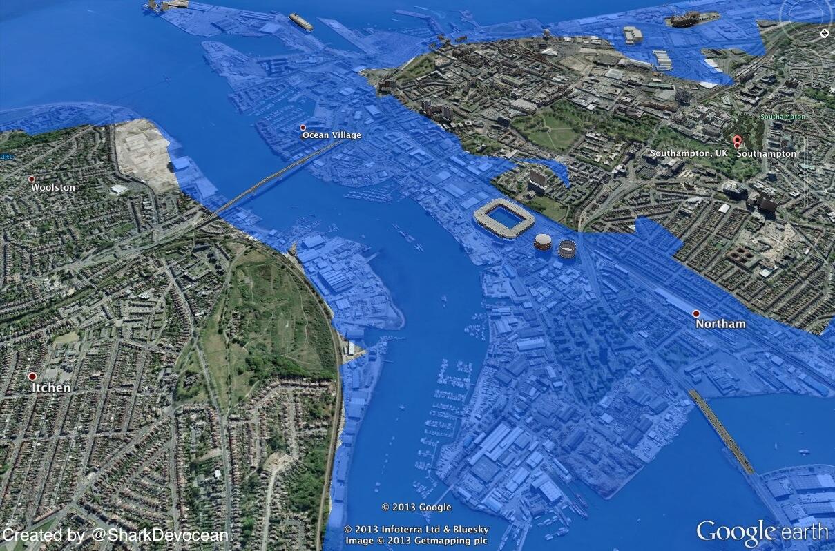
Effects of projected sea level rise on coral reefs
Source: SPC

Deeper bottom dwelling reefs will be especially affected as the level of sunlight penetration to such depths is reduced. Corals rely on a symbiotic relationship with algae as their main food source, as the light levels drop in deeper water, this symbiotic algae cannot produce enough food for themselves and the coral. As a result the coral is supplied less food, and is therefore less able to catch enough nutrients (phosphates, nitrates and proteins) from other sources to keep the algae properly fed. The symbiotic relationship therefore fails as they can no longer sustain each other.

All may not be lost however, as sea levels rise so does the area of habitats available for branching coral reefs. Coral reef growth itself is inhibited by declining or static sea levels, so as long as these levels don't rise too quickly it could be seen as a positive thing for the future of corals.

Looking at it from another point of view, rising sea levels are not the major threat to coral reefs at present. The other consequences of climate change such as the warming of sea surface temperatures and anthropological interferences can be thought of being the more pressing issues to be addressed when thinking about the future of corals.

Wednesday 4 December 2013

Mangroovy


With sea level rise comes the inevitable change in environmental conditions and pressures, with shores and coastlines at the forefront of the threat and therefore likely to be most affected. One such ecosystem selective to coastlines is those of Mangrove Forests. Mangals (Mangrove Forests) are extremely selective in the sense that they are highly adapted to saline conditions and thus can only form around coastlines in intertidal environments.

The distribution of mangroves globally is controlled by the 20° isotherm with mangrove forests found extensively around tropical coastlines, extending into subtropical areas as far north as st. Georges Parish  (32° 23’N) in Bermuda and as far south as Corner Inlet (38° 45’S) in Australia (Woodrolfe, 1990). Whilst abundant along shorelines they are particularly well developed in muddy and well sheltered areas of coast with a large supply of fine grained, silty sediment. They can however also form on peat, sand and coral substrates.


Map Showing World Distribution of Mangrove Forests
Source: (Giri, et.al, 2011)

As sea levels rise mangrove forests are being placed under increasing stress. This is due to the numerous negative effects seawater can have on coastal areas, including; sediment erosion, the inundation of habitats by seawater and increasing salinity levels in landward zones (Ellison, 1994). These effects put these ecosystems and the services they provide under threat. Services such as;

  • Trapping sediment, therefore sustaining offshore water quality for coral reefs,
  • Providing nursery habitats for fish and invertebrates that spent maturity in coral reef environments,
  • Acting as flood and surge protection for inland areas.
Mangrove forests can also be used as building materials, traditional medicines, firewood and as sources of food (Ellison, 1994).

Mangrove Forests as seen from below
Source: BBC Nature


It has been predicted that these coastal ecosystems are therefore likely to migrate landward as their former habitats become increasingly marine, this process will occur through the vertical accretion of sediments held by the extensive mangrove roots. 

However this retreating movement is hindered by an effect coined ' coastal squeeze', which means that their landward migration is becoming increasingly restricted by topography or human developments. (Ellison, 1991). With these woodlands now no longer able to shift inland as outer pressures increase, the question is where can/will they go?

Mangrove destruction on Bimi
Source: Kristine Stump

On another note however it must be said that currently the biggest threat to these diverse ecosystems is not sea level rise but human destruction of these coastal ecosystems to make room for our ever expanding populations (Luther, 2009).


Wednesday 27 November 2013

#Drownyourtown


Check out this new modelling service one group is using to bring sea level rise home!

#Drowyourtown

Using google maps and a 'sea level rise image' they produced visual representations of what cities would look like after an increase in sea level.  It was a novel outreach programme aimed at making people think about sea level rise, with people able to send in requests to see how their home town would look after a rise in sea level.

#Drownyourtown
Southampton, UK after a 10m rise in sea level
Source: Drownyourtown
Whilst it provides nice visualisations it has been stated by the group that such predictions lack validation and should therefore not be used for real estate speculations.

So what are you waiting for? Send your requests into @Drownyourtown and search #Drownyourtown and get connected with sea level rise, past maps also available on their blog:


Monday 25 November 2013

Fire and ice


VOLCANO, a word that strikes fear in the hearts of most. They even pose a sense of impending doom to those of us who don't live within dangerous distances from a smouldering crater. Ash clouds coupled with atmospheric cooling put our yearly summer holidays at risk as evidenced by the 2010 'icelandgate'.

Now we are at risk from volcanoes in another, less obvious fireball way. A volcano has recently been discovered through seismic profiling under a deep layer of antarctic ice which could cause a speed up the melting of antarctic ice and raise global sea level when it erupts.


Photograph of Mount Erubus, the most active volcano found on Antarctica
Source: National Geographic, by George Steinmetz


This volcano is covered by more than half a mile of ice, it is therefore doubtful that an eruption would breach the surface. The heat produced however is likely to increase melting at the base of  the glacier, causing millions of gallons of water to flow beneath the ice and affect stream flow (Lough, A, et.al., 2013). This water would act as a lubricant, increasing the speed with which the overlying ice flows into the sea. Whilst the subsequent sea level rise would be far from catastrophic, this is just yet another variable to be taken into account when thinking about future sea levels and our need for protection.


References
Lough, A, Et.al.. (2013). Seismic detection of an active subglacial magmatic complex in Marie Byrd Land, Antarctica. Nature Geoscience, doi:10.1038/ngeo1992.


Thursday 21 November 2013

Mammoth Island


Imagined Wooly Mammoth
Source: PSU

Mammoth is the name given to any species within the extinct genus Mammuthus. A large elephant like mammal equipped with long curved tusks and in some Northern latitude species, a long covering of hair. The Wooly mammoth, drawn above, being the classic example that springs to most minds when the word mammoth is mentioned.

These creatures roamed Europe, Africa, Asia and Northern America during The Pleistocene to the more recent holocene, until the majority died out across the major continents approximately 12,000 to 10,000 years BP.

While a definitive and wholly agreed upon reason for their gradual decline and subsequent extinction has yet to be agreed upon in the scientific community, environmental and anthropological causes are regularly cited.

The gradual warming of climate at the start of The Holocene is thought to be one possible driver of their dwindling numbers. The glacial retreat created by this warming and the change in vegetation from open woodland and grassland to more dense forests would have reduced available habitats for large species like Mammoths.

Humans also began having a greater hand in environmental change as the climate warmed and the vegetation cover became more favourable to hunting large predators. This caused the tables to turn, allowing humans to become the more dominant. Overhunting of the mammoth species for food and clothing may therefore have played a large part in their demise.

Wrangel island is a small island located in The Arctic Ocean, within the area known as Beringia (when above sea level) mentioned in previous blog posts. It has recently been discovered that a pygmy species of mammoth survived on this island way past those living on the major continents, up to 2000 years BCE (Vartanyan, 1993). Recent analysis has caused these wrangel island mammoths to no longer be considered dwarfs, (Vartanyan et.al, 2003).


Map showing rise in sea level in The Bering Strait with time.
a
f, Mammoth distribution (red) at 18,000 (a), 13,000 (b), 10,000 (c), 9,000 (d), 8,000 (e) and 4,000 (f) yr bp is shown.
Source: (Guthrie, 2004)


Why is it then that mammoths were able to survive so long, even in a smaller form, past their continent dwelling relatives?

This small island was cut off from the mainland continents when sea levels began rising due to the melting ice sheets towards the start of the holocene. This rise in sea level would have caused complete isolation from the rest of the world, leaving Wrangel Island untouched again by man until settlers inhabited the island.

One proposed theory is that this provides evidence for the major role humans played in driving mammoths to extinction. Another idea is that this small island provided an idyllic safe haven, with a persistent vegetation similar to that which mammoths thrived in during the colder climates in continental areas (Lozkhin, 2001). But were there no other wrangel type refugia for mammoths on the mainlands?

Whilst the true reason for the mammoths persistence on Wrangel Island is unknown, it can be said that the rise in sea level that caused the cut off of this island from the rest of the world may have saved these mammoths....... if only for a little while.

Thursday 14 November 2013

Humans + Nature = ?


Whilst not directly linked with sea level rise itself, this is a really interesting paper about the devastating effects contact with humanity can have on natural ecosystems previously untouched by man.

This coupled with my previous post about Beringia and the pathway it produced allowing migration into Northern America, a previously unpopulated area, provides a good look at how such land bridges formed by decline in sea level have brought about long term and ireversible changes to natural landscapes.

Whilst human population across the globe was most likely inevitable, whether by foot or by boat, the stage humanity was at when it crossed these oceans surely would have afffected the way we treated the land when it was finally breached.

Thursday 7 November 2013

A Bridge to Another Land


After looking at how changing sea levels are affecting humanity today, I now want to look at how these sea levels fluctuations affected past humans, allowing us to mould and alter the ecosystems unlocked to us.

During the Quaternary climate fluctuated between warm interglacial and cool glacial periods, during these glacial events water was locked up to various amounts in global ice sheets. This caused varying proportions of water allocated to storage in oceans. When glaciers expanded, ocean shorelines retreated, and in areas of low ocean depth the sea floor was exposed, in some cases creating land bridges between major continents and islands. These land bridges played a large part in the migration of early humans and our population across all major continents of the globe.

The Bering Land Bridge was an ancient land bridge approximately 1000 miles at its widest, which connected Asia to North America. It was in existence at various times during The Pleistocene ice ages, the series of glacial events during the Quaternary from 2.58 Ma to present. At these times sufficient water was locked up in permanent and fluctuating global ice sheets that sea level dropped low enough to expose the sea floor. Sea levels worldwide were thought to have at some times been lowered by as much as 120 meters.

Specifically it is thought the Bering Land Bridge was exposed during Oxygen Isotope Stage 3 (OIS3), between 60,000 and 25,000 cal BP, and cut off during Oxygen Isotope Stage 2 (OIS2).


Animation showing an approximation of the changing coastline of Beringia from 21,000 Cal years BP to present.
Source: NCDC

Many other land bridges were exposed in the same way during The Quaternary, such as the connection between Australia, New Guinea and Tanzania, as well as the dry beds of the English Channel and North Sea between The British Isles and mainland Europe.

The Bering land bridge, known as Beringia, is of particular interest as it is the suspected route of migration to The Americas from Asia approximately 21,000 Cal years BP. It was previously thought people simply left Siberia, crossed the Bering Land Bridge and passed onto the Canadian land mass through an ice free corridor. However recent investigations indicate that this ice free corridor was blocked between 30,000 and 11,500 Cal years BP. Archeological findings in Northern America and Beringia suggest that migrants may have lived on the Bering Land Bridge for millennia whilst their path was blocked by advancing ice sheets in Siberia and Canada.

Pollen studies used to reconstruct the climate of Beringia have suggested that between 29,500 and 13,300 Cal years BP it was cool and arid and dominated by a herb-grass-willow tundra.

This land bridge was completely inundated by rising sea levels, caused by melting ice sheets, sometime between 10,000 and 11,000 Cal years BP, as the climate began to give way to the warmer interglacial period we are experiencing today. Its current depth was reached approximately 7,000 Cal years BP.

Most evidence of Beringia has long since been wiped from the surface of the Earth, and whilst we now no longer require such land bridges to cross between continents, it is clear that in the past these strips of land played a defining role in shaping humanity's current presence across the globe as well as the major effects we've has shaping its surface.


References
 
Tamm E, Kivisild T, Reidla M, Metspalu M, Smith DG, Mulligan CJ, Bravi CM, Rickards O, Martinez-Labarga C, Khusnutdinova EK et al. 2007. Beringian Standstill and Spread of Native American Founders. PLoS ONE 2(9):e829.
 
D.M. Hopkins, et al. (1982). "Paleoecology of Beringia", New York: Academic Press.
 
Ager TA, and Phillips RL. 2008. Pollen evidence for late Pleistocene Bering land bridge environments from Norton Sound, northeastern Bering Sea, Alaska. Arctic, Antarctic, and Alpine Research 40(3):451–461.


Wednesday 30 October 2013

Shrinking States


The Alliance of Small Island States (AOSIS) is an intergovernmental organisation of low lying island nations, formed with the purpose of protecting these island populations most vulnerable to the adverse effects of climate change. AOSIS has 44 member states and observers, most located within the Atlantic, Pacific and Indian oceans.

One such small island state is Kiribati, located in the Central Pacific Ocean it is composed of 32 atolls and one raised coral island.


Video explaining the threats facing Kiribati from climate change and rising sea levels and social issues from within the state.

Source: The Global Mail


Rising sea levels will have numerous environmental and sociological effects on The island of Kiribati and its inhabitants, all culminating to a complete loss of island life, destroying the community and traditions of the Kiribati people.

The most obvious of these effects is the complete loss of land as sea levels rise and erosion is enhanced by the increased frequency and strength of storm surges. Whilst most coastal areas can retreat when inundated by water, due to Kiribati's narrow size there is nowhere for people to go except to flee to other atolls already under strain from overpopulation or leave Kiribati altogether.

Another effect of the rising sea levels is the salinization of freshwater, a scarce resource on islands surrounded by saline oceans. Freshwater sources for Kiribati’s island communities are restricted to rainwater, shallow unconfined groundwater, imported water or desalinated ocean water. More and more of these sources are now becoming contaminated by the infiltration of saline seas and anthropogenic waste caused by the extremely high (and ever increasing) population densities of these small islands (some being equal to those in large cities such as London, UK and New York, USA, without the high rise buildings).


The effects felt if these small islands are submerged under water are not only sociological they are also ecological, with many islands hosting rare species and ecosystems. 
Kiribati has great marine biodiversity with 120 species of corals and 520 species of fish. These coastal environments can survive some sea level rise, however most, such as coral reefs, rely on their placement within the photic zone where microscopic algae can best provide photosynthesis for the corals. Therefore when submerged below this zone, beneath the area of influence from the sun, coral reef growth is inhibited.

So the question is, Why should these vulnerable small islands be the ones feeling the greatest effect caused by humanity's hunger for development, when they themselves contribute so little to anthropogenic greenhouse gas emissions?


Graph showing the Greenhouse Gas contributions of The United Kingdom, United States and Kiribati in 2010 (LUCF - Land Use Change/Forestry).
Kiribati's contributions is so small relative to The UK and USA that it cannot be seen in comparison.
Source: World Resources Center; CAIT2.0

In 2010 Kiribati produced 0.11 Mt of GHG (including the effects of land use change and forestry), USA on the other hand produced a massive 6,775.45 Mt. A staggering contrast that small island states are feeling the main consequences of.


References


Bernard Lagan. (2013). Kiribati: A Nation Going Under. Available: http://www.theglobalmail.org/feature/kiribati-a-nation-going-under/590/. Last accessed 30/10/2013.


World Resources Institute. (2013). Available: http://cait2.wri.org/wri/Country%20GHG%20Emissions?indicator=Total%20GHG%20Emissions%20Excluding%20LUCF&indicator=Total%20GHG%20Emissions%20Including%20LUCF&year=2010. Last accessed 30/10/2013.


Thomson Reuters. (2013). Tide of humanity, as well as rising seas, lap at Kiribati's future. Available: http://www.reuters.com/article/2013/06/13/us-kiribati-climate-idUSBRE95C04L20130613. Last accessed 30/10/2013.


Alliance of Small Island States. (2013). s. Available: http://aosis.org/. Last accessed 30/10/2013.


Wednesday 23 October 2013

Taking it easy?


This blog post is a slight tangent to the main topic of sea level change but its an interesting argument about the validity of predictions being made regarding future sea level rise and its implications.

IPCC logo
An article in the journal Nature recently expressed concerns over the IPCC’s possible down playing of future predictions based on climate change. Whilst the overall article's subject was related to possible new sociological studies during the IPCC conferences, looking at the interactions between scientists during panel sessions where they discuss recent findings, model results and possible options for humanity.

There was however a small reference to recent sea level rise predictions and the fact that the IPCC chose to ignore the contributions of the Western Greenland ice sheet when publishing new projections for sea level rise. This was caused by an uncertainty into the validity of its modelling. The final assessment therefore projected a sea-level rise of up to 59 centimeters by 2100, even though many researchers currently predict a much larger rise.

Is the IPCC’s decision to downplay possible sea level rise due to uncertainty a good thing or is it simply a way of covering them from possible criticism if proved wrong?


Whilst it isn’t the time for scaremongering about unreasonable and untrue predictions this light and polite technique being used may be too soft on society. With the intention less on driving for support and publishing findings that have the majority consensus in the scientific community and more on covering the IPCC’s own back, in a tendency called ‘erring on the side of least drama (ESLD). Society may need a shock to get full attention on the problem at hand.

Here’s a link to the article:

http://www.nature.com/news/study-aims-to-put-ipcc-under-a-lens-1.13947


Another journal paper relevant to this subject can be found here:


It's titled ‘Climate change prediction: Erring on the side of least drama?’ and provides a discussion into whether the scientific community has begun releasing conservative predictions over the previously alarmist model projections in fear or social uproar and criticism if they are found wrong.

References
Jeff Tollefson. (2013). Study aims to put IPCC under a lens. Nature. 502 (7471), 281.

Brysse, Keynyn et.al. (2013). Climate change prediction: Erring on the side of least drama?. Global Environmental Change. 23 (1), p327-337.

Monday 21 October 2013

200 Million People in Danger


I want to start by looking at a general overview of the effects sea level rise will have on human society. Whilst this may seem a little egocentric, I thought it best to begin with something everyone can feel empathetic towards, humanity.
Here is a great animation showing the areas on Earth likely to be flooded if sea water were to rise anywhere up to 6m. Whilst this amount of sea level rise is unlikely to occur in the near future it is not a completely unfathomable scenario for The Earth’s future.


Figure based upon findings in the IPCC Special Report on Emissions Scenarios (SRES), showing number of people estimated to be flooded in coastal areas in 2080 as a result of sea level rise.

 
The animation coupled with the graph above (showing populations likely to be affects by a sea level rise of up to 1m) really highlights the huge number of people that could and will be affected by future sea level rise, and the possible colossal consequences for human society, based on proximity to coastline and GDP/capita.
Some might argue that the human race has survived such rises in sea level in the past and whilst this is true, humanity has now evolved in such a way that past survival strategies used by such early humans are no longer applicable.
 
In the past when such changes in sea level made a region untenable its inhabitants would have been able to pack up and move on, rather than fighting the natural changes that were occurring. In present times due to the build-up of infrastructure in at risk areas and the large populations living at or below sea level, human society has lost some of their ability to adapt to these changes, therefore such a solution is no longer viable.
 
Society itself has also become more stubborn and unwilling to face the fact that while we are currently the dominant species involved in shaping this planet, it has not been and will not be that way forever. Changes in sea level have occurred throughout Earth’s history and will continue to occur for its foreseeable future, whether we are here to feel its effects or not.
Therefore we need to understand that it is possible we shouldn’t be changing the earth to mould around our needs, maybe we should be adapting based upon what the changes the earth and its systems are experiencing, especially since 9/10 times it is humanity that has induced such changes which are disrupting the natural order of things.
 
Even if greenhouse gas emissions were stabilised today sea level would continue to rise for centuries into the future due to the timescales involved with climate dynamics and the related processes and feedback mechanisms attached. Large amount of resources are therefore being placed in research into the development of new technologies capable of defending our coastlines and societies from rising sea levels. The question is though, how much longer can we hold off the inevitable destruction of our coastlines?


References
David Braaten et.al. (2006). Global Sea Level Rise. Available: https://www.cresis.ku.edu/sites/default/files/sea-level-rise/anim/world.mov. Last accessed 20/10/2013.
Nicholls, R.J. and Lowe, J.A. (2006) Climate stabilisation and impacts of sea-level rise. In Avoiding Dangerous Climate Change (eds. H.J. Schellnhuber, W. Cramer, N. Nakicenovic, T.M.L. Wigley, and G. Yohe). Cambridge University Press, Cambridge.
Nicholls, R.J. and Tol, R.S.J. (2006). Impacts and responses to sealevel rise: a global analysis of the SRES scenarios over the twenty-firstn century. Philos. Trans. R. Soc. Lond. A, 364, 1073-1095.
UNEP: Global outlook for Ice & Snow Estimates of people flooded in coastal areas in the 2080s as a result of sea level rise and for given socio-economic scenarios and protection responses. (June 2007). In UNEP/GRID-Arendal Maps and Graphics Library. Retrieved 20/10/2013. Available: http://maps.grida.no/go/graphic/estimates-of-people-flooded-in-coastal-
areas-in-the-2080s-as-a-result-of-sea-level-rise-and-for-given-socio-economic-scenarios-and-
protection-responses.

Thursday 17 October 2013

A Present Danger


Figure 1 - Graph showing past average global sea level values and projections for the future based upon scenarios run by The IPCC.
Source: The IPCC Fourth Assessment Report: Climate Change 2007.


“Global average sea level rose at an average rate of 1.8 ± 0.5 mm per year over 1961 to 2003 and at an average rate of about 3.1 ± 0.7 mm per year from 1993 to 2003.”[1]

These were the findings presented in the Intergovernmental Panel on Climate Change (IPCC); Climate Change Synthesis Report (2007).

Theses finding show a marked increase in rate of sea level change from 1993 to 2003, this may simply be due to natural decadal variations in sea level, it could however also signify a more alarming problem, the effects recent anthropogenic warming is having on the rate of sea level change.

Such increases in sea level will have major effects on societies, both those in low lying coastal areas likely to be flooded, and those that will feel the secondary effects caused by increased pressure from displaced populations looking for refuge on their lands and resources. Not to mention the massive environmental impacts caused by the flooding and disruption (if not in most cases destruction) of unique ecosystems that form where land and water intersect.

This disruption/destruction will be the main theme discussed in the next few months within these blog posts.


References

[1] -Bindoff, N.L., J. Willebrand, V. Artale, A, Cazenave, J. Gregory, S. Gulev, K. Hanawa, C. Le Quéré, S. Levitus, Y. Nojiri, C.K. Shum, L.D. Talley and A. Unnikrishnan, 2007: Observations: Oceanic Climate Change and Sea Level. In: Climate Change 2007: The Physical Science Basis. Contribution of Working Group I to the Fourth Assessment Report of the Intergovernmental Panel on Climate Change [Solomon, S., D. Qin, M. Manning, Z. Chen, M. Marquis, K.B. Averyt, M. Tignor and H.L. Miller (eds.)]. Cambridge University Press, Cambridge, United Kingdom and New York, NY, USA.

Thursday 10 October 2013

We've gotta start somewhere


Figure 1 - A map of Europe showing an imagined alarmist coastline plan if all The Earth's ice were to melt, which at current rates it is estimated could occur within 5000 years.
Map: National Geographic


In this blog I plan to look at the effects eustatic sea level fluctuations have had on planet earth and its inhabitants, from the naturally induced fluctuations of the Late Quarternary to the more alarming increase in sea level since the mid 1800’s, (The recent Anthropocene - if you believe we have entered a new epoch of human influence) and even to the future, looking at possible outcomes of the predicted rising.

First i'll set the scene by explaining some of the main factors that cause such fluctuations in global absolute sea level over the earths history. Eustatic sea level is mainly influenced by changes in the volume of water found in the oceans. It is however also affected by morphological changes to the earth’s surface resulting from tectonics, subsidence, glacial isostatic rebound and sedimentation, which alter the volume of the ocean basins which contain the water.

There are two major factors which cause the volume of ocean water to change on a global scale, the amount of water locked up in oceans vs. other reservoirs, and the temperature of the ocean at the time.
The thermal expansion coefficient of H2O is such that when placed at higher temperatures the volume of a body of water expands, therefore when earth experiences an increase in surface temperature the oceans will be heated and the water will expand accordingly, greater volume of water in the oceans means a higher eustatic sea level (other factors remaining the same).

An increase in surface temperature also leads to the melting of glaciers and ice sheets, causing a greater percentage of the earth’s water to be held in the oceans relative to other reservoirs, increasing eustatic sea level. Anthropogenic factors such as land hydrology can also affect the relative proportion of water storage in oceans against land reservoirs, however this occurs on a more regional scale and therefore its effects are generally felt over shorter timescales.

Although humans may not be directly pumping the vast majority of water into the oceans that is causing sea levels to rise so drastically, we are responsible for the intense period of warming The Earth is currently experiencing (although that is another debate for another blog). It is this warming that is causing modern eustatic sea level rise that is threatening so many of earth's present day ecosystems and societies.

I’ll end this post with a link to the 2007 IPCC report on climate change, specifically the chapter titled; Observations: Oceanic Climate Change and Sea Level., which goes into the subject of what causes sea level rise in more depth and is a good read if you are interested in the subject of sea level rise or oceans in general.


References

Bindoff, N.L., J. Willebrand, V. Artale, A, Cazenave, J. Gregory, S. Gulev, K. Hanawa, C. Le Quéré, S. Levitus, Y. Nojiri, C.K. Shum, L.D. Talley and A. Unnikrishnan, 2007: Observations: Oceanic Climate Change and Sea Level. In: Climate Change 2007: The Physical Science Basis. Contribution of Working Group I to the Fourth Assessment Report of the Intergovernmental Panel on Climate Change [Solomon, S., D. Qin, M. Manning, Z. Chen, M. Marquis, K.B. Averyt, M. Tignor and H.L. Miller (eds.)]. Cambridge University Press, Cambridge, United Kingdom and New York, NY, USA.

Pirazzoli, P (1996). Sea-level changes - The Last 20000 Years. Chichester: John Wiley & Sons. p5-15.