Tuesday 7 January 2014

Greenlands Little Secret


Happy holidays everyone! Sorry about the lack of posts in the past few weeks, been very busy with festive cheer and less cheery deadlines!

Thought i'd just keep you up to date with a new study I found recently in Nature Geoscience which could have some serious repercussions for global sea level responses to melting.

A drill rig was used to extract old snow cores from within the Greenland snow aquifer. 
(Photo: Evan Burgess) 

An enormous aquifer has been discovered under greenland's ice sheet. This aquifer was found accidentally by glaciologists as they drilled for ice cores in southeastern greenland in 2011. It is more than 27,000 sq. miles large according to data from NASA's operation ice bridge radar, meaning it holds an estimated 154 billion tons of water, fed by meltwater that flows through the Greenland ice sheet.


A thin section of a core extracted from the aquifer by Koenig's team is held in front of the sun.
Image Credit: NASA's Goddard Space Flight Center/Ludovic Brucker 

If released it would be enough to raise global sea levels by .04cm, which may not seem that much considering sea levels already rise by more each year because of melting ice sheets. The importance of this discovery however comes from what it could do for our understanding of how meltwater moves through the greenland ice sheet into the seas, which when considering the acceleration of ice loss from Greenland in recent years, is important when predicting the effect warming has on melting and sea level rise.


The full article can be found here.

Thursday 19 December 2013

Innocent And Under Threat


A new report has stated that 17% of America's threatened and endangered species are at risk from rising sea levels. This is a shocking amount of species put in danger because of humanity and our hunger for power, so I thought i'd have a little look at the 5 species currently at most risk from sea levels in America.

Key deer - A deer species that only lives in Florida endangered due to the inundation of the island that they are found on.
Source

Loggerhead sea turtle suffering due to the disappearance of beaches where they lay their eggs.
Source

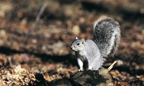
Delmarva Fox Squirrel endangered due to the inundation from Chesapeake Bay.
Source

Western Piping Plover due to the inundation of beaches where they feed and nest.
Source

Hawaiian Monk Seal put at risk due to the reduction of beaches through rising seas.
Source


Poor little things! But is it too late to save them?

Sunday 15 December 2013

Saving Nemo


Vibrant Coral Reef
Source: Guardian, Photography: Mark Conlin/Alamy 

Coral reefs are beautiful and dynamic ecosystems that provide critical resources for marine diversity as well as a source of recreational activities, making them vital to the viability of coastal communities. As well as economic and aesthetic services they also provide protection from storm waves, act as habitats and nurseries for fish species and produce sand for the development of beaches.


To create a global view of coral reefs, over 1700 images (red boxes) from the Landsat 7 spacecraft were collected for the Millennium Coral Reef Mapping Project.
Source: NASA

Coral reef development is a very long process and can take thousands of years. As marine organisms with calcium carbonate skeletons die their skeletons break down and become calcium carbonate sediments. These sediments fill in the framework of the reef and cement together constructing a foundation upon which the reef grows upwards and outwards.


Formation of the 3D structure of coral reefs
Source: USGS

Due to their selective environmental requirements these reefs are at risk during periods of changing ocean conditions, such as the present. The number of threats to these coral reefs has increased substantially in the past few decades due to the increasing levels of atmospheric carbon dioxide and the onset of anthropogenic climate change, leading to changes in marine environments (Kleypas, 1999). The most important of these in regards to coral reefs are ocean acidification, increasing sea surface temperature AND sea level rise.

It was first thought that sea level rise wouldn't pose that great of a threat to coral reef communities, at least in the shorter term. This was because the rate of modern sea level rise was previously slower than coral reef growth rates, and that they could therefore 'keep up' with increasing sea levels. This rate of sea level rise has increased substantially in recent years due to increasing inputs from continental ice sheets (Milne, 2009) and our improving understanding of ice sheet dynamics.

However it has been said that healthy shallow water corals may still be able to grow at rates such that they manage to keep up with modern sea level rise and colonise new areas. The key word here is 'healthy', whilst coral reefs under no other major stresses may be able to grow fast enough to escape the oncoming tides, reefs already suffering and dwindling due to increased acid levels, temperature and anthropogenic influences are far from at their optimum conditions and their growth may be inhibited well below natural levels.

If the rate of sea level rise does exceed coral growth rate then they, specifically those with large terrestrial sediment sources in close proximity, will be put at greater risk from enhanced sedimentation rates and turbidity, both being major stresses to coral reefs (Pandolfi et.al, 2003; Fabricius, 2005). A rise in sea level of just 0.2 meters (at the lower end of predictions for this century) has the potential to increase turbidity through two mechanisms:
  • Increased resuspension of fine sediment.
  • Increased coastal erosion and subsequent input of sediment able to be transported to the reef flats. (Field et.al, 2011)

Effects of projected sea level rise on coral reefs
Source: SPC

Deeper bottom dwelling reefs will be especially affected as the level of sunlight penetration to such depths is reduced. Corals rely on a symbiotic relationship with algae as their main food source, as the light levels drop in deeper water, this symbiotic algae cannot produce enough food for themselves and the coral. As a result the coral is supplied less food, and is therefore less able to catch enough nutrients (phosphates, nitrates and proteins) from other sources to keep the algae properly fed. The symbiotic relationship therefore fails as they can no longer sustain each other.

All may not be lost however, as sea levels rise so does the area of habitats available for branching coral reefs. Coral reef growth itself is inhibited by declining or static sea levels, so as long as these levels don't rise too quickly it could be seen as a positive thing for the future of corals.

Looking at it from another point of view, rising sea levels are not the major threat to coral reefs at present. The other consequences of climate change such as the warming of sea surface temperatures and anthropological interferences can be thought of being the more pressing issues to be addressed when thinking about the future of corals.

Wednesday 4 December 2013

Mangroovy


With sea level rise comes the inevitable change in environmental conditions and pressures, with shores and coastlines at the forefront of the threat and therefore likely to be most affected. One such ecosystem selective to coastlines is those of Mangrove Forests. Mangals (Mangrove Forests) are extremely selective in the sense that they are highly adapted to saline conditions and thus can only form around coastlines in intertidal environments.

The distribution of mangroves globally is controlled by the 20° isotherm with mangrove forests found extensively around tropical coastlines, extending into subtropical areas as far north as st. Georges Parish  (32° 23’N) in Bermuda and as far south as Corner Inlet (38° 45’S) in Australia (Woodrolfe, 1990). Whilst abundant along shorelines they are particularly well developed in muddy and well sheltered areas of coast with a large supply of fine grained, silty sediment. They can however also form on peat, sand and coral substrates.


Map Showing World Distribution of Mangrove Forests
Source: (Giri, et.al, 2011)

As sea levels rise mangrove forests are being placed under increasing stress. This is due to the numerous negative effects seawater can have on coastal areas, including; sediment erosion, the inundation of habitats by seawater and increasing salinity levels in landward zones (Ellison, 1994). These effects put these ecosystems and the services they provide under threat. Services such as;

  • Trapping sediment, therefore sustaining offshore water quality for coral reefs,
  • Providing nursery habitats for fish and invertebrates that spent maturity in coral reef environments,
  • Acting as flood and surge protection for inland areas.
Mangrove forests can also be used as building materials, traditional medicines, firewood and as sources of food (Ellison, 1994).

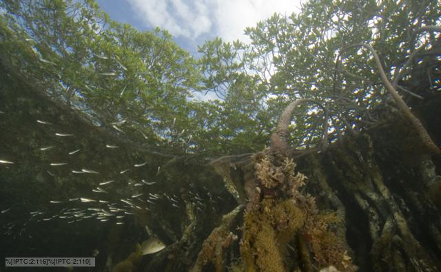
Mangrove Forests as seen from below
Source: BBC Nature


It has been predicted that these coastal ecosystems are therefore likely to migrate landward as their former habitats become increasingly marine, this process will occur through the vertical accretion of sediments held by the extensive mangrove roots. 

However this retreating movement is hindered by an effect coined ' coastal squeeze', which means that their landward migration is becoming increasingly restricted by topography or human developments. (Ellison, 1991). With these woodlands now no longer able to shift inland as outer pressures increase, the question is where can/will they go?

Mangrove destruction on Bimi
Source: Kristine Stump

On another note however it must be said that currently the biggest threat to these diverse ecosystems is not sea level rise but human destruction of these coastal ecosystems to make room for our ever expanding populations (Luther, 2009).


Wednesday 27 November 2013

#Drownyourtown


Check out this new modelling service one group is using to bring sea level rise home!

#Drowyourtown

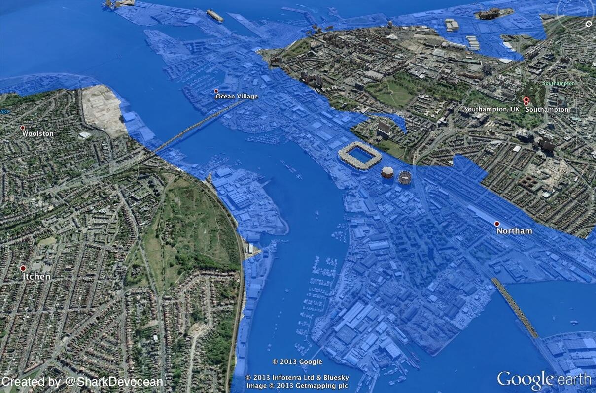
Using google maps and a 'sea level rise image' they produced visual representations of what cities would look like after an increase in sea level.  It was a novel outreach programme aimed at making people think about sea level rise, with people able to send in requests to see how their home town would look after a rise in sea level.

#Drownyourtown
Southampton, UK after a 10m rise in sea level
Source: Drownyourtown
Whilst it provides nice visualisations it has been stated by the group that such predictions lack validation and should therefore not be used for real estate speculations.

So what are you waiting for? Send your requests into @Drownyourtown and search #Drownyourtown and get connected with sea level rise, past maps also available on their blog:


Monday 25 November 2013

Fire and ice


VOLCANO, a word that strikes fear in the hearts of most. They even pose a sense of impending doom to those of us who don't live within dangerous distances from a smouldering crater. Ash clouds coupled with atmospheric cooling put our yearly summer holidays at risk as evidenced by the 2010 'icelandgate'.

Now we are at risk from volcanoes in another, less obvious fireball way. A volcano has recently been discovered through seismic profiling under a deep layer of antarctic ice which could cause a speed up the melting of antarctic ice and raise global sea level when it erupts.


Photograph of Mount Erubus, the most active volcano found on Antarctica
Source: National Geographic, by George Steinmetz


This volcano is covered by more than half a mile of ice, it is therefore doubtful that an eruption would breach the surface. The heat produced however is likely to increase melting at the base of  the glacier, causing millions of gallons of water to flow beneath the ice and affect stream flow (Lough, A, et.al., 2013). This water would act as a lubricant, increasing the speed with which the overlying ice flows into the sea. Whilst the subsequent sea level rise would be far from catastrophic, this is just yet another variable to be taken into account when thinking about future sea levels and our need for protection.


References
Lough, A, Et.al.. (2013). Seismic detection of an active subglacial magmatic complex in Marie Byrd Land, Antarctica. Nature Geoscience, doi:10.1038/ngeo1992.


Thursday 21 November 2013

Mammoth Island


Imagined Wooly Mammoth
Source: PSU

Mammoth is the name given to any species within the extinct genus Mammuthus. A large elephant like mammal equipped with long curved tusks and in some Northern latitude species, a long covering of hair. The Wooly mammoth, drawn above, being the classic example that springs to most minds when the word mammoth is mentioned.

These creatures roamed Europe, Africa, Asia and Northern America during The Pleistocene to the more recent holocene, until the majority died out across the major continents approximately 12,000 to 10,000 years BP.

While a definitive and wholly agreed upon reason for their gradual decline and subsequent extinction has yet to be agreed upon in the scientific community, environmental and anthropological causes are regularly cited.

The gradual warming of climate at the start of The Holocene is thought to be one possible driver of their dwindling numbers. The glacial retreat created by this warming and the change in vegetation from open woodland and grassland to more dense forests would have reduced available habitats for large species like Mammoths.

Humans also began having a greater hand in environmental change as the climate warmed and the vegetation cover became more favourable to hunting large predators. This caused the tables to turn, allowing humans to become the more dominant. Overhunting of the mammoth species for food and clothing may therefore have played a large part in their demise.

Wrangel island is a small island located in The Arctic Ocean, within the area known as Beringia (when above sea level) mentioned in previous blog posts. It has recently been discovered that a pygmy species of mammoth survived on this island way past those living on the major continents, up to 2000 years BCE (Vartanyan, 1993). Recent analysis has caused these wrangel island mammoths to no longer be considered dwarfs, (Vartanyan et.al, 2003).


Map showing rise in sea level in The Bering Strait with time.
a
f, Mammoth distribution (red) at 18,000 (a), 13,000 (b), 10,000 (c), 9,000 (d), 8,000 (e) and 4,000 (f) yr bp is shown.
Source: (Guthrie, 2004)


Why is it then that mammoths were able to survive so long, even in a smaller form, past their continent dwelling relatives?

This small island was cut off from the mainland continents when sea levels began rising due to the melting ice sheets towards the start of the holocene. This rise in sea level would have caused complete isolation from the rest of the world, leaving Wrangel Island untouched again by man until settlers inhabited the island.

One proposed theory is that this provides evidence for the major role humans played in driving mammoths to extinction. Another idea is that this small island provided an idyllic safe haven, with a persistent vegetation similar to that which mammoths thrived in during the colder climates in continental areas (Lozkhin, 2001). But were there no other wrangel type refugia for mammoths on the mainlands?

Whilst the true reason for the mammoths persistence on Wrangel Island is unknown, it can be said that the rise in sea level that caused the cut off of this island from the rest of the world may have saved these mammoths....... if only for a little while.