Wednesday, 27 November 2013

#Drownyourtown


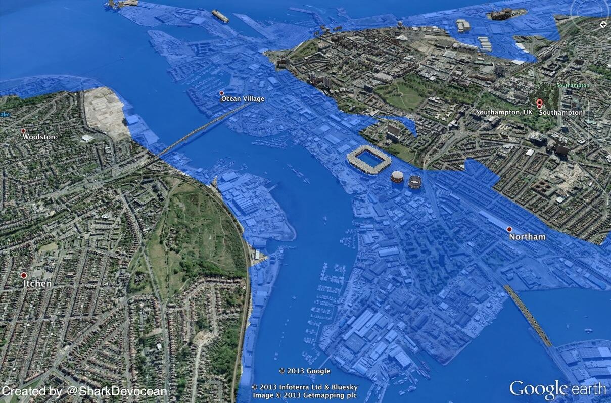
Check out this new modelling service one group is using to bring sea level rise home!

#Drowyourtown

Using google maps and a 'sea level rise image' they produced visual representations of what cities would look like after an increase in sea level.  It was a novel outreach programme aimed at making people think about sea level rise, with people able to send in requests to see how their home town would look after a rise in sea level.
#Drownyourtown
Southampton, UK after a 10m rise in sea level
Source: Drownyourtown
Whilst it provides nice visualisations it has been stated by the group that such predictions lack validation and should therefore not be used for real estate speculations.

So what are you waiting for? Send your requests into @Drownyourtown and search #Drownyourtown and get connected with sea level rise, past maps also available on their blog:


Monday, 25 November 2013

Fire and ice


VOLCANO, a word that strikes fear in the hearts of most. They even pose a sense of impending doom to those of us who don't live within dangerous distances from a smouldering crater. Ash clouds coupled with atmospheric cooling put our yearly summer holidays at risk as evidenced by the 2010 'icelandgate'.

Now we are at risk from volcanoes in another, less obvious fireball way. A volcano has recently been discovered through seismic profiling under a deep layer of antarctic ice which could cause a speed up the melting of antarctic ice and raise global sea level when it erupts.


Photograph of Mount Erubus, the most active volcano found on Antarctica
Source: National Geographic, by George Steinmetz


This volcano is covered by more than half a mile of ice, it is therefore doubtful that an eruption would breach the surface. The heat produced however is likely to increase melting at the base of  the glacier, causing millions of gallons of water to flow beneath the ice and affect stream flow (Lough, A, et.al., 2013). This water would act as a lubricant, increasing the speed with which the overlying ice flows into the sea. Whilst the subsequent sea level rise would be far from catastrophic, this is just yet another variable to be taken into account when thinking about future sea levels and our need for protection.


References
Lough, A, Et.al.. (2013). Seismic detection of an active subglacial magmatic complex in Marie Byrd Land, Antarctica. Nature Geoscience, doi:10.1038/ngeo1992.


Thursday, 21 November 2013

Mammoth Island


Imagined Wooly Mammoth
Source: PSU

Mammoth is the name given to any species within the extinct genus Mammuthus. A large elephant like mammal equipped with long curved tusks and in some Northern latitude species, a long covering of hair. The Wooly mammoth, drawn above, being the classic example that springs to most minds when the word mammoth is mentioned.

These creatures roamed Europe, Africa, Asia and Northern America during The Pleistocene to the more recent holocene, until the majority died out across the major continents approximately 12,000 to 10,000 years BP.

While a definitive and wholly agreed upon reason for their gradual decline and subsequent extinction has yet to be agreed upon in the scientific community, environmental and anthropological causes are regularly cited.

The gradual warming of climate at the start of The Holocene is thought to be one possible driver of their dwindling numbers. The glacial retreat created by this warming and the change in vegetation from open woodland and grassland to more dense forests would have reduced available habitats for large species like Mammoths.

Humans also began having a greater hand in environmental change as the climate warmed and the vegetation cover became more favourable to hunting large predators. This caused the tables to turn, allowing humans to become the more dominant. Overhunting of the mammoth species for food and clothing may therefore have played a large part in their demise.

Wrangel island is a small island located in The Arctic Ocean, within the area known as Beringia (when above sea level) mentioned in previous blog posts. It has recently been discovered that a pygmy species of mammoth survived on this island way past those living on the major continents, up to 2000 years BCE (Vartanyan, 1993). Recent analysis has caused these wrangel island mammoths to no longer be considered dwarfs, (Vartanyan et.al, 2003).


Map showing rise in sea level in The Bering Strait with time.
a
f, Mammoth distribution (red) at 18,000 (a), 13,000 (b), 10,000 (c), 9,000 (d), 8,000 (e) and 4,000 (f) yr bp is shown.
Source: (Guthrie, 2004)


Why is it then that mammoths were able to survive so long, even in a smaller form, past their continent dwelling relatives?

This small island was cut off from the mainland continents when sea levels began rising due to the melting ice sheets towards the start of the holocene. This rise in sea level would have caused complete isolation from the rest of the world, leaving Wrangel Island untouched again by man until settlers inhabited the island.

One proposed theory is that this provides evidence for the major role humans played in driving mammoths to extinction. Another idea is that this small island provided an idyllic safe haven, with a persistent vegetation similar to that which mammoths thrived in during the colder climates in continental areas (Lozkhin, 2001). But were there no other wrangel type refugia for mammoths on the mainlands?

Whilst the true reason for the mammoths persistence on Wrangel Island is unknown, it can be said that the rise in sea level that caused the cut off of this island from the rest of the world may have saved these mammoths....... if only for a little while.

Thursday, 14 November 2013

Humans + Nature = ?


Whilst not directly linked with sea level rise itself, this is a really interesting paper about the devastating effects contact with humanity can have on natural ecosystems previously untouched by man.

This coupled with my previous post about Beringia and the pathway it produced allowing migration into Northern America, a previously unpopulated area, provides a good look at how such land bridges formed by decline in sea level have brought about long term and ireversible changes to natural landscapes.

Whilst human population across the globe was most likely inevitable, whether by foot or by boat, the stage humanity was at when it crossed these oceans surely would have afffected the way we treated the land when it was finally breached.

Thursday, 7 November 2013

A Bridge to Another Land


After looking at how changing sea levels are affecting humanity today, I now want to look at how these sea levels fluctuations affected past humans, allowing us to mould and alter the ecosystems unlocked to us.

During the Quaternary climate fluctuated between warm interglacial and cool glacial periods, during these glacial events water was locked up to various amounts in global ice sheets. This caused varying proportions of water allocated to storage in oceans. When glaciers expanded, ocean shorelines retreated, and in areas of low ocean depth the sea floor was exposed, in some cases creating land bridges between major continents and islands. These land bridges played a large part in the migration of early humans and our population across all major continents of the globe.

The Bering Land Bridge was an ancient land bridge approximately 1000 miles at its widest, which connected Asia to North America. It was in existence at various times during The Pleistocene ice ages, the series of glacial events during the Quaternary from 2.58 Ma to present. At these times sufficient water was locked up in permanent and fluctuating global ice sheets that sea level dropped low enough to expose the sea floor. Sea levels worldwide were thought to have at some times been lowered by as much as 120 meters.

Specifically it is thought the Bering Land Bridge was exposed during Oxygen Isotope Stage 3 (OIS3), between 60,000 and 25,000 cal BP, and cut off during Oxygen Isotope Stage 2 (OIS2).


Animation showing an approximation of the changing coastline of Beringia from 21,000 Cal years BP to present.
Source: NCDC

Many other land bridges were exposed in the same way during The Quaternary, such as the connection between Australia, New Guinea and Tanzania, as well as the dry beds of the English Channel and North Sea between The British Isles and mainland Europe.

The Bering land bridge, known as Beringia, is of particular interest as it is the suspected route of migration to The Americas from Asia approximately 21,000 Cal years BP. It was previously thought people simply left Siberia, crossed the Bering Land Bridge and passed onto the Canadian land mass through an ice free corridor. However recent investigations indicate that this ice free corridor was blocked between 30,000 and 11,500 Cal years BP. Archeological findings in Northern America and Beringia suggest that migrants may have lived on the Bering Land Bridge for millennia whilst their path was blocked by advancing ice sheets in Siberia and Canada.

Pollen studies used to reconstruct the climate of Beringia have suggested that between 29,500 and 13,300 Cal years BP it was cool and arid and dominated by a herb-grass-willow tundra.

This land bridge was completely inundated by rising sea levels, caused by melting ice sheets, sometime between 10,000 and 11,000 Cal years BP, as the climate began to give way to the warmer interglacial period we are experiencing today. Its current depth was reached approximately 7,000 Cal years BP.

Most evidence of Beringia has long since been wiped from the surface of the Earth, and whilst we now no longer require such land bridges to cross between continents, it is clear that in the past these strips of land played a defining role in shaping humanity's current presence across the globe as well as the major effects we've has shaping its surface.


References
 
Tamm E, Kivisild T, Reidla M, Metspalu M, Smith DG, Mulligan CJ, Bravi CM, Rickards O, Martinez-Labarga C, Khusnutdinova EK et al. 2007. Beringian Standstill and Spread of Native American Founders. PLoS ONE 2(9):e829.
 
D.M. Hopkins, et al. (1982). "Paleoecology of Beringia", New York: Academic Press.
 
Ager TA, and Phillips RL. 2008. Pollen evidence for late Pleistocene Bering land bridge environments from Norton Sound, northeastern Bering Sea, Alaska. Arctic, Antarctic, and Alpine Research 40(3):451–461.